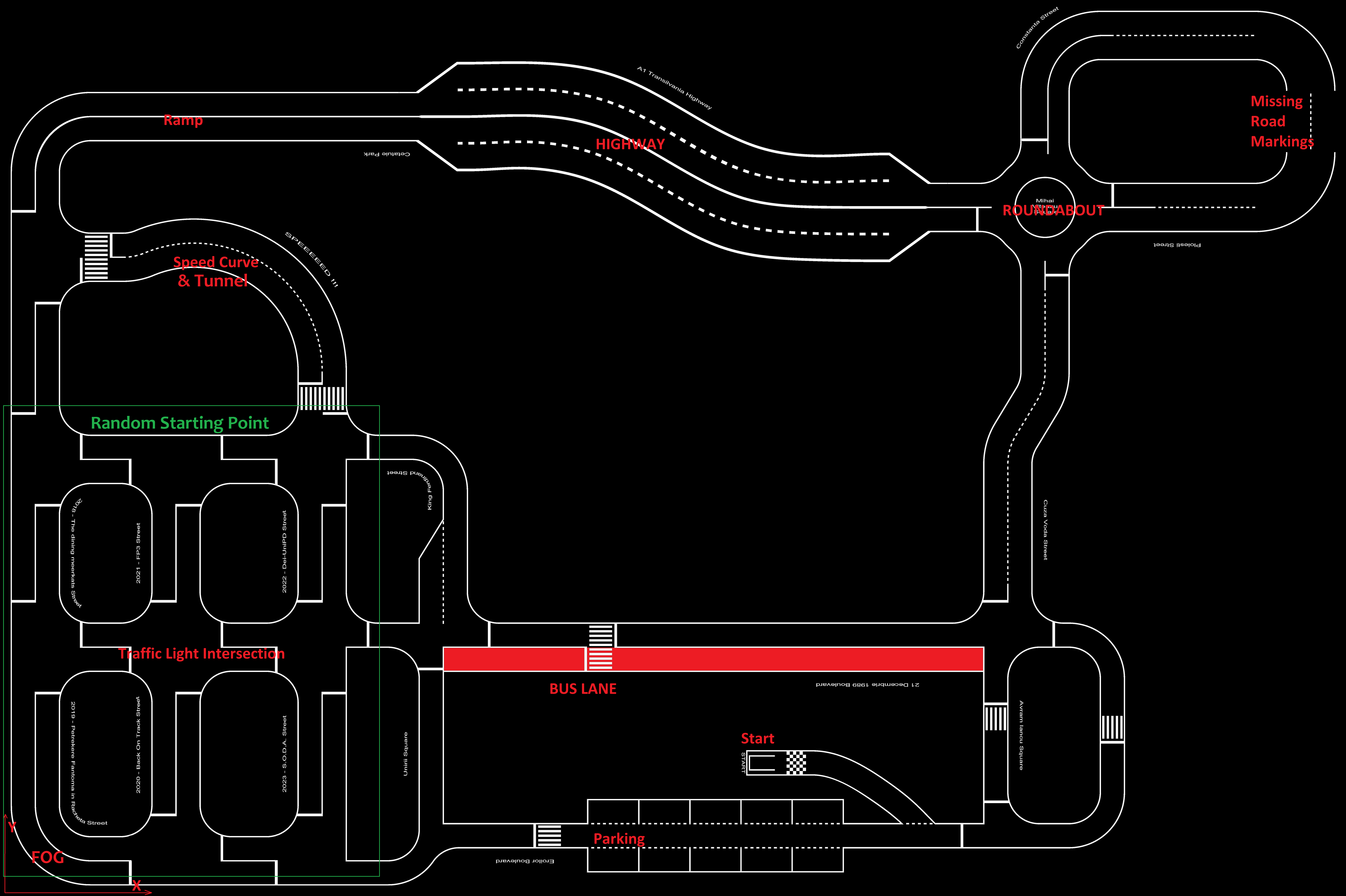
The track
The competition map will be included in the official documentation. It is designed to simulate a variety of scenarios and environmental conditions, all of which are described in the Scoring and Prizes section. The track layout adheres to the competition’s traffic rules, which are detailed further below.
Road markings
- The track features various road elements such as:
Straight road sections,
Curves,
Crosswalks,
One-way roads,
Two-way roads,
Highways,
Intersections (with 3- or 4-way junctions)
Parallel parking spots,
Roundabouts,
Ramp,
Missing road sections,
Bus lane,
Tunnel.
The lane width is around 35 cm wide, while the lanes are 2 cm wide (unless specified otherwise).
Detailed dimensions of each element are provided in the competition documentation.
Trafic rules
- The vehicle must adhere to general traffic rules:
Right-Side Driving: The vehicle must drive on the right side of the road, on the right lane.
- Line Markings:
Dashed Line: The vehicle must overtake obstacle vehicles if it’s safe to do so.
Continuous Line: The vehicle must tail the encountered obstacle vehicle and is not allowed to overtake.
Pedestrian at Crosswalk: When a pedestrian signals the intention to cross the street (i.e., is slightly within road markings) at the crosswalk, the vehicle must stop until the pedestrian has crossed.
Pedestrian on Road: When a pedestrian is encountered in the middle of the road, whether surrounded by dashed lines or not, the vehicle must stop and wait for the pedestrian to pass.
Highway Lane Usage: On a highway, the vehicle must drive on the second lane (the margin one).
Roundabout navigation: When inside the roundabout, vehicle must navigate it counter-clockwise.
- Speed limitations
Highway area: Minimum 40 cm/s
city area: Minimum 20 cm/s
BUS Lane: It’s not to be touched by the vehicle.
The following action should be taken when the specified road signalling is encountered (each can be encountered):
Name |
Description |
|---|---|
Traffic light |
RED - vehicle must stop and wait. Green - vehicle must proceed. Yellow Vehicle must proceed with caution. |
Traffic sign - Stop |
The vehicle must halt 3 seconds before the intersection. |
Traffic sign - Parking |
The vehicle must visibly slow down, find an empty parking spot and then park. |
Traffic sign - Crosswalk |
The vehicle must visibly slow down on crosswalk. |
Traffic sign - Priority |
The vehicle must go into the intersection without stopping. |
Traffic sign - Highway entry |
The vehicle must adhere to highway rules. |
Traffic sign - Highway end |
The vehicle must adhere to city rules. |
Traffic sign - One-way |
Indicates a one-way road that the vehicle must follow. |
Traffic sign - roundabout |
Indicates a roundabout; the vehicle must follow the roundabout rules. |
Traffic sign - no-entry |
Indicates a non-entry road which the vehicle must avoid. |
Vehicle-to-everything
The competition provides a set of systems that handle the connectivity aspect of the challenge. These systems replicate a smart city environment and offer participants multiple ways to develop their projects, allowing them to fuse and validate data, as well as to request and exchange shared information.
- The systems that will be available are:
A localization system
A live traffic monitor
Smart traffic lights
- Localization system
It is a physical box that will be placed on top of the car itself during the run on the track.
It has the purpose of retrieving the car position on the track, and it shares this position with the Traffic Communicaiton Server
The system has a maximum error radius of 20 cm and a delay of up to 0.5 seconds, broadcasting position data at custom frequency between 0.2 - 5 Hz.
- Traffic communication system
Each car must send data to an in-house traffic communication system, including vehicle speed and vehicle position once every 3 seconds or less.
Each car must send data to an in-house traffic communication system regarding the enctoutnered obstacles (once per obstacle), includes obstacle position and type.
This data is used to reconstruct and evaluate the run the vehicle has just completed.
- Smart traffic light
Traffic lights share their status on the network, indicating their color state, and their position on the map. The frequency of the sent messages being of 1 Hz.
Ambient disturbance
Certain areas of the track experience varying light conditions, including shaded areas and direct sunlight. The position of such places is not static.
Map
Here you can find the competition map with the road markings and the rough position of each fixed element.
